01 October 2006
72. Virgin Territory
Black Sheep H3 - 1 Octobeer 2006
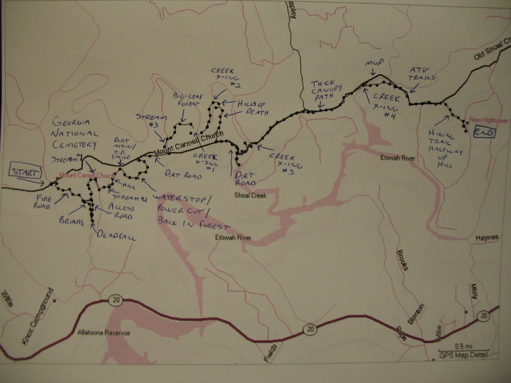
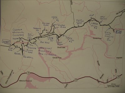 Click on the photo for a larger view. We had a couple hounds ask us about the area, so here's more info than any sane person needs:
Hares: Red Breast and L&F
Length: 6 miles.
Start: Next to Mount Caramel Church, between Cartersville and Canton
End: Near New Hightower Church
------
THE AREA
Mount Carmel Church Road was carved from a ridgeline north of Hwy 20 between Canton and Cartersville. The ridgeline is quickly apparent when you start scouting the area, because getting back to it sometimes requires climbing up some lung-busting hills.
As for the church itself, it was built sometime when Jesus was alive. If you’re lucky, you can be in the area to hear the minister screaming to the congregation when church is in session and the doors are open.
Next to the church is the new Georgia National Cemetery. It lies on 775 acres that were donated by a WWII veteran and land developer. It is meant to serve more than 400,000 honorably discharged veterans that live within 75 miles of the site. Because of the work being done, the property was clear cut, and a couple miles of the old road were cleared and widened. Some connecting roads got the same treatment. In addition to the clear-cut roads, there’s also an access road on parts of the south side of the property near the treeline, which was built for drainage. Veterans are already being buried at the cemetery, although construction is far from finished.
On the other end of the road is New Hightower Church. The old church was dubbed Hell’s Church, partly because of its remote location inside the treeline. It was built in the late 1800’s, replacing the old log cabin that served the congregation. Vandals burned it down in 1990, and the “new” New Hightower Church was built in a more conspicuous place across the street from the nearby cemetery. Paranormal experts came to the area to “investigate” in 2004 and found nothing. The current church is still vandalized on occasion.
Because Mount Carmel Church Road is no longer driveable, getting between the two churches is a 14-mile drive. That means the shortest route is the old road. Heading from west to east, you have the option of cutting through the cemetery to the left of Mt. Carmel Church, or winding your way down a hunting road to the right of the church. The actual dirt road starts about a mile in, and this is where the Wildlife Management Area begins. About halfway between the churches, the road becomes overgrown or washed out in spots. And about 3/4 of the way across, the road disappears near the alleged site of an old bridge that we found no remnants of.
Interesting sites near the road are vertical cliffs, tons of creeks and a magnolia forest with leaves bigger than a toddler. At one point, the ATV trails become really narrow and look more like hiking trails, complete with a really thick canopy and totally blocks out the sun. Closer to New Hightower Church is a forestry area that the local high school runners use for their cross-country trails. As you have probably guessed, there are quite a few possibilities here.
------
THE TRAIL
For our annual trail this time around, we did something local, if you consider 40-50 miles from downtown local. Red Breast searched through a number of Wildlife Management Areas and found this one, which was far enough out so we could assume it was virgin territory. I drew the WMA map on top of my GPS map and we drove up to the area for the first time a month early.
We spent part of that first day driving around, trying to find ways to get into the area, as well as places for a start and an end. One of our first stops was New Hightower Church. We ran into some groundskeepers there, and they gave us a big history and geography lesson. The biggest piece of info was that the road we were on used to go all the way to Mount Caramel Church about 4 miles to the west, now a dirt road through the WMA and the property for the new Georgia National Cemetery. We gradually made our way over to Mount Caramel Church and found a way to the WMA from there, without having to use too much clear-cut land from the Cemetery. We scouted to the first creek crossing, but it had just rained and the creek was too deep and moving too fast to cross. We knew we'd have to walk back to the car, so we ended the day there.
For our second day a week later, we met at the end and drove one car to the start. This is the day we found the dirt mountain and decided it would be interesting to put a TP face on it. The dirt mountain was where we entered the Cemetery property, and stayed in it just long enough to make a beeline to the dirt road. The scenic views on this part of the Cemetery property are amazing, with the Etowah River valley to the south and the Blue Ridge Mountains to the north. The creek was much lower this time around, so we crossed it and thought we could cross it again to keep going east. No luck. On the east side of the creek were almost totally vertical cliffs. We headed away from the dirt road until the crossing was possible, if you call two lung-busting hills possible.
The scenery changed here a bit, as the dirt road became a little overgrown and then totally disappeared. Some parts looked like hiking paths, and the thick canopy made the area so gorgeous, it became a perfect way to bust the monotony of straight forest running. The area here is perfect ATV territory, so we ran into a few riders while we were out. One of the guys gave us another history lesson. Apparently, there are remnants of a cannonball factory nearby. The last area on trail was a straight shot to the church through the forest. There was a trail here, winding halfway up a hill. There was even surveyor's tape down the length of it.
We both did a third day, but not together. She re-scouted her part, and I re-checked mine. My last day was the day before trail, and I walked the entire thing, finding a place for a water stop and adding the TP smile on the dirt mountain. I wish someone would have videotaped me up there on the mountain, clinging for dear life while trying to find enough rocks to secure the toilet paper. Oh, and me swatting at an annoying bumblebee who decided my yellow shirt was the world's largest flower.
Here's the insane part: I ran and biked for three freaking weeks to get back in shape so I could hare this trail, and got my 10K down to 53 minutes. But I still got snared three times. Jesus. I love Black Sheep but those 5-minute head starts suck ass.
Thank you to everyone who drove so far to do this trail.
May the Hash Get a Piece
# posted by L&F @ 8:38 PM 
![]()
